
MTB 6 - Le Trévezel forest - graded green
3 points of interest

La fougère aigle - Béatrice Galzin 
The hidden life of the forest
Trees grow upwards towards the light while mosses benefit from their shade on the ground and spread out. Like soft cushions or carpets, they hug everything that sticks out of the ground, such as old tree stumps. This soft felted surface is pleasing to see, and an undergrowth without mosses would not be worthy of the name. Legend has it that mosses show which way is north. Wrong!
Mosses indicate a degree of moisture; they protect the soil from drying out by retaining every last drop of dew. They prepare pockets of humus for the future occupants: grasses and herbaceous plants. They also love the damp of tree trunks and can grow there, on the side that is most exposed to the prevailing rains.
Sous bois du Trévezel - Béatrice Galzin The Mont Aigoual forest
“Aigoual, Forêt d’Exception”
The French Forestry Office, which manages state forests, launched a programme in 2013 called “Aigoual, Forêt d’Exception” (Aigoual: An Exceptional Forest) with the aim of highlighting the massif’s natural and cultural heritage. The Forestry Office thus tries to foreground the different aspects of its multi-facetted management: production, protection and receiving visitors. One key aspect of this approach, which complements other initiatives by local actors, is to improve visitors’ experience in the forest.
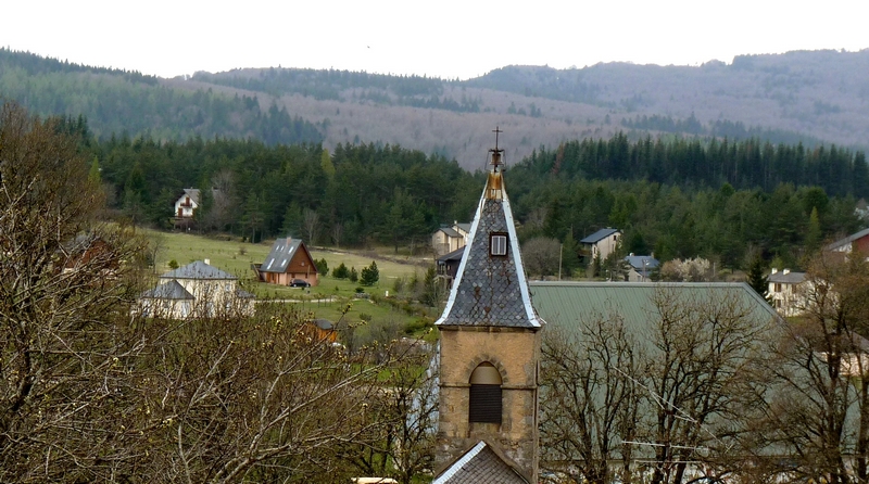
Camprieu - nathalie.thomas 
Camprieu
In the 19th century, the village streets were bustling year-round with a throng of artisans, labourers and shopkeepers, who lived in these modest mountain houses that were also suitable for livestock rearing. Camprieu had: two cobblers, six clog makers, two basket makers, one carpenter, two wheelwrights, two farriers, one miller, two stonemasons, one glassworks, one sawmill, one dairy, two grocer’s shops, a haberdashery and ironmonger’s and one shop for ladies’ “fashion and dresses”. There was also a cheese cellar that produced Roquefort until 1932, a hotel and an inn.
Description
Signposts will guide you all along this route. In the description below, the signposted place names and/or directions are given in bold italics between quotation marks:
Start at “Camprieu” near the stadium, heading southeast. Go through the crossroads
- “Le Cros”, then
- “Tabarde”, then head to
- “Maison du Bois”. Go towards
- “Tailladette” and head left towards “Taillade”.
- At "Taillade" continue straight to “Bois de l’Agre”.
- From "Bois de l'Agre" go back to “Taillade” via a beautiful descent and come back to the village using the same route as at the start: "Tailladette", "Maison du bois", "Tabarde", "Le Cros" and "Camprieu".
This circuit is taken from the guidebook Massif de l’Aigoual, published by the communauté de communes Causses Aigoual Cévennes as part of the collection Espaces naturels gardois and the label Gard Pleine Nature.
- Departure : St Sauveur Camprieu
- Arrival : St Sauveur Camprieu
- Towns crossed : Saint-Sauveur-Camprieu
Forecast
Altimetric profile
Recommandations
Caution: patous (livestock guardians)! Seek advice on how to behave near these dogs from tourist offices and National Park information centres.
Before committing yourself to a circuit, ensure that it is suitable for your activity level and ability. You must wear a helmet; further protective equipment is recommended. Respect other road users and stay in control of your speed and trajectory. Make sure your equipment is appropriate for the day’s weather conditions. Remember that the weather changes quickly in the mountains. Take enough water. Please close all gates and barriers behind you. No off-roading.
Information desks

Tourism & national parc'house
Col de la Serreyrède, 30570 Val d'Aigoual
The Maison de l'Aigoual houses the tourism office Mont Aigoual Causses Cévennes and the Maison du Parc national. This visitor centre provides information on and raises awareness of the Cévennes National Park, its sites and events as well as the rules that must be observed in the National Park's central zone.
On site: changing exhibitions, video projections, Festival Nature events and shop Open year-round
Transport
liO is the regional public transport service of the Occitanie/ Pyrénées – Méditerranée region. It facilitates everyone’s movements by prioritising public transport. For more information, call 08 10 33 42 73 or go to www.laregion.fr
Access and parking
From Meyrueis or Valleraugue, take the D986 to St-Sauveur - Camprieu – Parking.
Parking :
Source


Report a problem or an error
If you have found an error on this page or if you have noticed any problems during your hike, please report them to us here: