
The wood pigeon
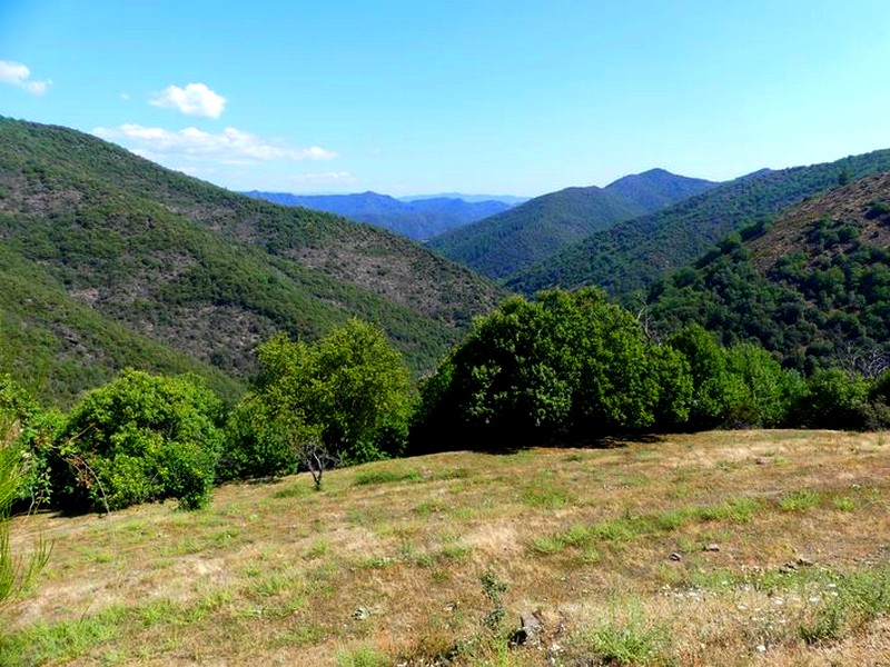
This path is living testimony to the history of the Cévennes. Livestock farmers continue to graze their herds here, thus shaping and maintaining these open spaces. Located on a ridge on a drovers’ road, Bonperrier is a rest stop for sheep and shepherds moving up to summer pastures. The views are wide-ranging: Mont Aigoual and Mont Lozère on one side and the Hérault valley on the other, with the sea in the background !
3 points of interest

l'Auberge-relais de Bonperrier - Michel Monnot 
Bonperrier and its inn
Legend has it that up on the Bonperrier ridge, just before the Great War, there was an inn run by two families. The crossroads was a lively place of exchange. The former King’s Road running north-south is also the limit between two municipalities.
Ridge roads were faster, and the coaching inns located alongside them offered travellers warm and dry overnight stays as well as fresh horses so that they could pursue their journey. Postmen came with the post but also with stories from the neighbouring valleys. In June, transhumant shepherds and their flocks still stay over at Bonperrier before going on to their summer pastures the next morning. Their stopover always turns into a convivial evening even if the inn no longer exists.
Le genêts à balai - Béatrice Galzin  Flora
FloraCommon broom
Common broom dominates on the sides of the path. Not appreciated by shepherds or their sheep, this tough legume was harshly condemned by the Cévenol writer Jean-Pierre Chabrol. For him, agricultural abandonment closed the landscape of the Cévennes by making way for broom, which signals the end of a civilisation.
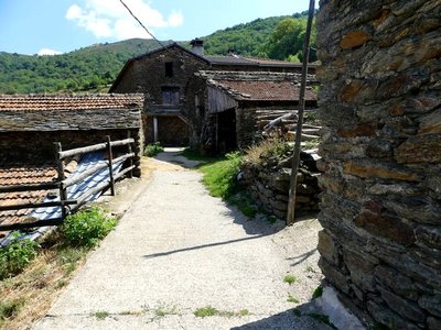
Les ruelles du hameau - Nathalie Thomas The hamlet of La Bessède
As you leave the woods, a vast landscape opens up near the hamlet of La Bessède. This complex of houses huddled together is typical in its isolation and dominant position. It is still inhabited. A dozen people (as compared to 80 a century ago) continue to farm sheep, in particular. Every year, several hundred sheep are sold for their meat. This explains the presence of so many makeshift watering troughs: enamelled bath tubs and chestnut trunks filled with water from nearby springs.
Description
Signposts will guide you all along this route, as well as yellow painted waymarks. In the description below, the signposted place names and/or directions are given in bold italics between quotation marks:
From the "La Bessède" car park, walk towards "Bonperrier" on the forest track.
- At the "Bonperrier" pass, turn left onto the track towards
- "Lacam", then
- “Crouzinal”. Leave the ridge track and take the path on the left that goes steeply downhill, following the signs for
- "les Sagnes" and "La Béssède". Return to the "La Béssède" car park.
- Departure : La Bessède (Les Plantiers)
- Arrival : La Bessède (Les Plantiers)
- Towns crossed : Les Plantiers
Forecast
Altimetric profile
Recommandations
Before committing yourself to a circuit, ensure that it is suitable for your activity level and ability. Remember that the weather changes quickly in the mountains. Take enough water. Please close all gates and barriers behind you. Caution: Sheep pastures with patous (livestock guard dogs)! Seek advice on how to behave near these dogs from tourist offices and National Park information centres. Keep your dog on a leash.
Information desks

Tourism & national parc'house
Col de la Serreyrède, 30570 Val d'Aigoual
The Maison de l'Aigoual houses the tourism office Mont Aigoual Causses Cévennes and the Maison du Parc national. This visitor centre provides information on and raises awareness of the Cévennes National Park, its sites and events as well as the rules that must be observed in the National Park's central zone.
On site: changing exhibitions, video projections, Festival Nature events and shop Open year-round

Tourism office Mont Aigoual Causses Cévennes, Saint-André-de-Valborgne
les quais, 30940 Saint-André-de-Valborgne
This office is part of the National Park's associated tourist-information network, whose mission is to provide information on, and raise awareness of, the sites and events as well as the rules that must be observed in the National Park's central zone.
Transport
LiO is the regional public transport service of the Occitanie/ Pyrénées – Méditerranée region. It facilitates everyone’s movements by prioritising public transport. For more information, go to the lio Occitanie app or visit https://www.mestrajets.lio.laregion.fr
(in term time)
Access and parking
From St-Jean du Gard towards St-André de Valborgne on the D907. After the village of Saumane, turn left onto the D20 to Les Plantiers. In Les Plantiers, take the road on the left (D20) and then, at the next crossroads, below the hamlet of Souliès, turn right onto the D20A which will take you to the hamlet of La Bessède.
Parking :
Source


Report a problem or an error
If you have found an error on this page or if you have noticed any problems during your hike, please report them to us here: